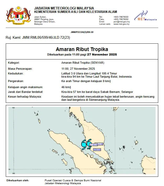



KUALA LUMPUR, November 27 – Malaysia is on high alert as Tropical Storm Senyar moves into the Straits of Malacca, prompting MetMalaysia to issue widespread warnings for heavy rain, strong winds and rough seas across much of Peninsular Malaysia from November 27 to 29.
Detected north of Sumatra and located 102km southwest of Lumut, Perak, the storm is tracking southeast at 24 km/h and is expected to bring severe weather to western and central states. MetMalaysia director-general Mohd Hisham Mohd Anip said continuous rainfall warnings, including severe-level alerts, have been issued for Kedah, Penang, Perak, Terengganu, Selangor, Kuala Lumpur, Putrajaya, and parts of Pahang.
With additional alert-level advisories for Kelantan, Negeri Sembilan, Melaka and Johor. Although Malaysia typically lies outside the tropical storm pathway due to its equatorial position, Senyar marks a rare occurrence—only two storms, Greg (1996) and Vamei (2001), have made direct landfall in the past.
Authorities warn that the current system, capable of producing wind speeds up to 50 km/h, may worsen flood conditions already affecting several regions, where residents have been forced to evacuate to temporary relief centres. MetMalaysia has been issuing updates every three hours since the storm entered its monitoring zone on November 23.
And continues to advise the public to remain vigilant during the peak of the Northeast Monsoon. The public is urged to stay updated through the myCuaca app, MetMalaysia’s website and official social media platforms, or contact the hotline at 1-300-22-1638 for the latest forecasts and emergency advisories.